For all those seeking answers to the ever looming question "What are we going to do this weekend?" For those who get home from work or school and sit in front of their depressing TV in their depressing apartment, wishing they had an idea for something awesome, adrenaline-filled, and potentially life threatening. Get off the couch. Do something crazy. Welcome to my life.
Whenever you drive by point of the mountain there are always people paragliding and naturally I've always wanted to try it. After meeting the owner of Two Can Fly Paragliding, I finally had the chance.
Video courtesy of Jason Williams. Subscribe!
Unlike skydiving you can take a beginner lesson and learn to fly solo. Going tandem on something like that just seems degrading so that was the main draw for me. Don't worry, there is ample instruction and practice before you even get off the ground. As you start to get more comfortable, you start launching from higher and higher up the hill. For the beginner lesson, the highest you get is probably 60 feet off the ground which is still a lot of fun. For the second time lesson however, you can start from the top of the hill.
I highly recommend it.
It was pretty exhausting carrying your harness and chute back up the hill each time.
Thanks to our instructor, Alex and Two Can Fly Paragliding.
Leprechaun Canyon is the most popular of the Irish Canyons located in the North Wash area about 30 miles south of Hanksville.
Video courtesy of Jason Williams. Subscribe!
If you're comfortable with squeezing, downclimbing, and awkward rappels off of cairn anchors, you might want to check this one out. Of the three forks, the East Fork is the easiest, and most scenic. The Middle and West Forks are extremely challenging with extensive sections of Mae West slot (sections so narrow you can't hike in the bottom forcing you to stem between the walls, often very high off the ground). So make sure you're dropping into the correct drainage. A few years back some guys dropped into the Middle Fork thinking they were in the East Fork and got stuck. One guy tried to climb out and fell from the rim to the canyon floor fracturing his skull. Luckily search and rescue got there in time to get him the medical attention he needed and save his life. So make sure you know where you're going
I get most of my beta from climb-utah.com and I recommend you do the same however for this canyon I would change it up a little bit. Their beta says to take the green dotted route below to access the canyon, but I recommend taking it from the start. The GPS coordinates for my drop in point are 38.036912, -110.518734. It adds three rappels the longest being 25 feet, and is not more challenging than the rest of the canyon. Also you go through some really cool sections of slot that you would otherwise miss.
From the trailhead hike up the canyon to where a side drainage enters from the left. Hike up the buttress between the side drainage and the main canyon and follow the ridge line up and around to your desired fork.
Adding some flare to the approach hike.
Overlooking the three forks.
Not the safest way to defeat a pothole, but definitely more fun than getting wet.
We almost stayed dry. There were two short pools after the technical section.
Turned out to be a swimmer.
Walking through the big subway section at the end.
This and the kiddie narrows below are accessible to hikers.
For all your explicit canyoneering beta, join the circle of friends at climb-utah.com
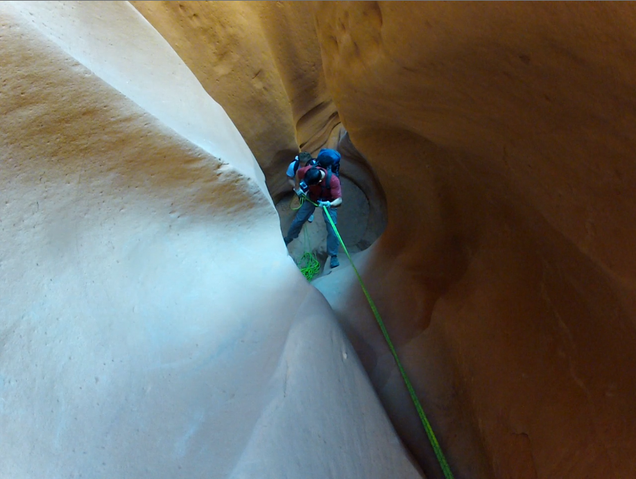
Not being a Harry Potter fan, I was a little hesitant to do this canyon, but after looking at some pictures I decided to get over my non-conformist attitude. Hogwarts Canyon is a short but sweet slot canyon 33 miles south of Hanksville in the North Wash Area. Make sure to check out the video below.
A short but tight squeeze.
The trailhead is located at Hog Spring Rest Area 33 miles south of Hanksville. This quaint little picnic area has bathrooms, covered picnic tables, and a cool little suspension bridge crossing the stream. This same trailhead accesses Hog Spring Waterfall, and some petroglyphs. The approach hike is pretty straightforward with some very mild scrambling in a couple places. Seventy-five yards after crossing the suspension bridge there will be a drainage on the left (southeast). Follow the ravine to the left of the drainage and keep heading southeast. You will need to route find your way up a second ravine up to the southeastern horizon. Once on top you will be able to see Hogwarts Canyon. Route find your way to the bottom and follow Hogwarts all the way to the highway. Once at the highway it is only 1/4 mile back to the trailhead. Take a look at the map below and you should be able to figure it out pretty easily.
There are four mandatory rappels in the canyon with a possible 5th if you really want to. The longest rappel is 85 feet so you'll want to bring a 60 meter rope along. The technical section of the canyon consists of two quick rappels (the second is through the cool arch feature), a stem/wade depending on ability, a short pack-off squeeze, another stem/wade, and two more rappels to finish it off. It's short but it has a lot of cool features and is a lot of fun. Trying to stay dry makes for a fun challenge.
There are several good primitive campsites in the area just right off the highway.
The Sandthrax campground is the most popular (38.016249, -110.531732).
Trying to keep the rope dry on the second rappel.
Jumping over a small pool after the second rappel.
A short section of stemming.
Coming down the last rappel.
The short walk back up the highway to the trailhead.
Video courtesy of Jason Williams. Subscribe!
For a full detailed route description including GPS waypoints, join the circle of friends at climb-utah.com.